Garður Lighthouse and Kleifarvatn: Iceland's Quiet Photography Spots
Two overlooked Reykjanes Peninsula stops near Keflavík Airport: the twin Garður lighthouses and the slowly shrinking lake Kleifarvatn, and exactly when and how to shoot each one.
Garður Lighthouse and Kleifarvatn: Iceland's Quiet Photography Spots
If your Iceland feed looks anything like mine, it is wall to wall Jökulsárlón icebergs, Kirkjufell at blue hour, and the same three angles of Reynisfjara's black sand. All of that is worth seeing. None of it is the first or last thing most photographers actually point a camera at, because most of us land at Keflavík Airport exhausted, drive straight past two genuinely interesting spots sitting almost on the runway's doorstep, and only notice them on the way home when the light has already gone.
Those two spots are the Garður lighthouses on the Reykjanes Peninsula's northern tip, and Kleifarvatn, a long dark lake a short drive inland that has quietly lost a fifth of its surface since the year 2000. Neither will headline a travel blog's "top ten Iceland photos" list, and I am not going to pretend otherwise. What they will do is turn a dead arrival morning or a last departure afternoon into something worth having the camera out for, without adding a single extra night to your itinerary. This guide covers both: what makes each one worth the stop, when to shoot them, how to get between them, and exactly how much time to actually budget.
Key Takeaways
Two quiet, easy-to-reach Reykjanes Peninsula spots that work as a natural bookend to an Iceland trip near Keflavík Airport.
| Point | Details |
|---|---|
| Two lighthouses, not one | The 1897 original (11.4 m, iron-reinforced concrete) stands near the shoreline; the 1944 replacement (28.6 m) sits 215 m inland, built after erosion undermined the first |
| Best light | Garður rewards sunset and blue hour; Kleifarvatn rewards stillness, usually early morning or a calm overcast afternoon |
| Kleifarvatn's real story | The lake has lost more than 20 percent of its surface area since the 2000 Iceland earthquakes, part of an active Mid-Atlantic Ridge fissure zone |
| Proximity | Both sit on the Reykjanes Peninsula close to Keflavík Airport, making them natural first or last stops rather than a dedicated day trip |
| Honest expectation | Neither is a bucket-list drive on its own. They reward photographers already passing through, not a special detour from Reykjavík |
| Real itinerary fit | Both appear as a possible opening stop on WeShoot's 7 day Iceland Winter Aurora tour, which begins at Keflavík Airport |
Table of Contents
- Why start or end your Iceland trip here
- Garður: two lighthouses, one quiet point
- When to shoot Garður lighthouse
- Kleifarvatn: Iceland's shrinking, shifting lake
- When to shoot Kleifarvatn
- Getting there and driving between them
- What to pack and plan for
- Where this fits on a real itinerary
- Frequently asked questions
Why start or end your Iceland trip here
I will say the honest thing up front, because every other article about Garður lighthouse either oversells it or ignores the question entirely: this is not a spot worth rearranging your itinerary to reach. One visitor review I came across while researching this piece put it bluntly, calling the lighthouse "not worth changing your plans for." I agree with that, and I think it is a more useful thing to tell you than another breathless description of a photogenic lighthouse. What Garður and Kleifarvatn actually are is something better suited to how most Iceland trips really work: a free fifteen to thirty minutes that sits almost directly between Keflavík Airport and the rest of the country, for photographers who are already driving past.
Compare that to Jökulsárlón, Kirkjufell, or Reynisfjara, each of which demands hours of driving and a committed block of your itinerary. Garður and Kleifarvatn demand almost nothing extra. Land at Keflavík, pick up your rental car, and both are reachable before you even properly start your trip, or on the way back to catch a flight when every other stop has already closed its shooting window for the day. That is the actual case for including them, and it is a stronger one than most location-scout listicles give it credit for.
Garður: two lighthouses, one quiet point
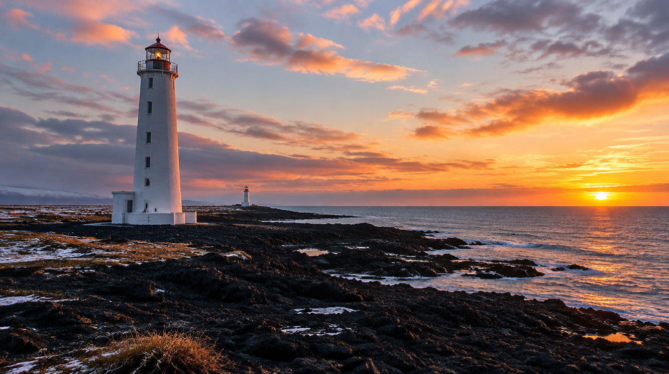
Most visitors do not realize Garður has two lighthouses standing within sight of each other, and that is the first thing worth knowing before you shoot there. The original, Garðskagaviti, was built in 1897 by the Royal Danish Lighthouse Commission: an 11.4 meter square tower made from iron-reinforced concrete, one of the earliest lighthouses of its kind in Iceland. For nearly five decades it did its job, until coastal erosion and sea spray began undermining its foundation badly enough that a replacement became necessary.
That replacement is the taller tower you will see dominating most photographs of the site today. Construction started on June 11, 1944, and remarkably the whole structure was finished in just three months, built 215 meters southeast of the original to put it on firmer ground. At 28.6 meters from foundation to top, it is well over double the height of its predecessor, and its light was converted from its original source to electric power in 1946, which extended the beam's range from 13 to 15.5 nautical miles (details via Wikipedia's entry on Garðskagaviti). The older 1897 tower has been a protected cultural heritage site since December 1, 2003, and a small maritime museum opened beside it in 1995, which is worth a quick look if you have the extra ten minutes.
Photographically, this gives you a genuine choice rather than one obvious shot. The 1897 tower, lower and set closer to the water, makes a cleaner subject for a minimal composition against open sea and sky, especially with a longer lens compressing it against a sunset. The 1944 tower is the better anchor for a wide shot that includes both structures in frame, since its height and inland position let you work the two lighthouses as a layered composition, one near, one far, both visible without a drone.
Pro Tip: Shoot from the shoreline rocks south of the newer tower in the last hour before sunset and you can often get both lighthouses in one frame, the older tower silhouetted against the water and the taller 1944 tower catching the last warm light. Mind your footing on wet rock, the wind off this exposed point is rarely gentle.
When to shoot Garður lighthouse
Sunset and blue hour are the strongest windows here, and for a straightforward reason: the point faces open water to the west and north, so you get an unobstructed horizon for the light to fall into, without a mountain range cutting the sky short the way it does at many Icelandic coastal spots. In winter, when the sun sits low for most of the day anyway, you can realistically shoot productively for an hour or more either side of sunset rather than chasing a narrow golden hour window. Our full guide to golden hour photography in Iceland goes deeper into reading that low winter light if you want the technical detail.
Aurora potential exists here too, though it comes with one practical complication nobody mentions: the lighthouse beam itself is a working aid to navigation, so it sweeps the sky periodically and can intrude on a long exposure if you are framing the tower directly beneath the aurora. Plan your composition so the beam sweeps away from your main subject, or time your shutter between sweeps. Before heading out on any aurora attempt here, check the Icelandic Meteorological Office's own forecasting page, which combines a six hour stepped cloud cover map with a 0 to 9 activity scale and local darkness and moonrise times for the Reykjavík area (en.vedur.is aurora forecast), since this flat, low lying point gives you almost no shelter if cloud rolls in off the sea.
Wind is the other factor that shapes every shoot here, more than most visitors expect. Garður sits on an exposed point with essentially nothing between it and the open Atlantic, so bring a sturdy tripod, weigh it down if you have a hook or a sandbag, and keep a lens cloth handy for sea spray on your front element during anything breezier than a calm day.
Kleifarvatn: Iceland's shrinking, shifting lake
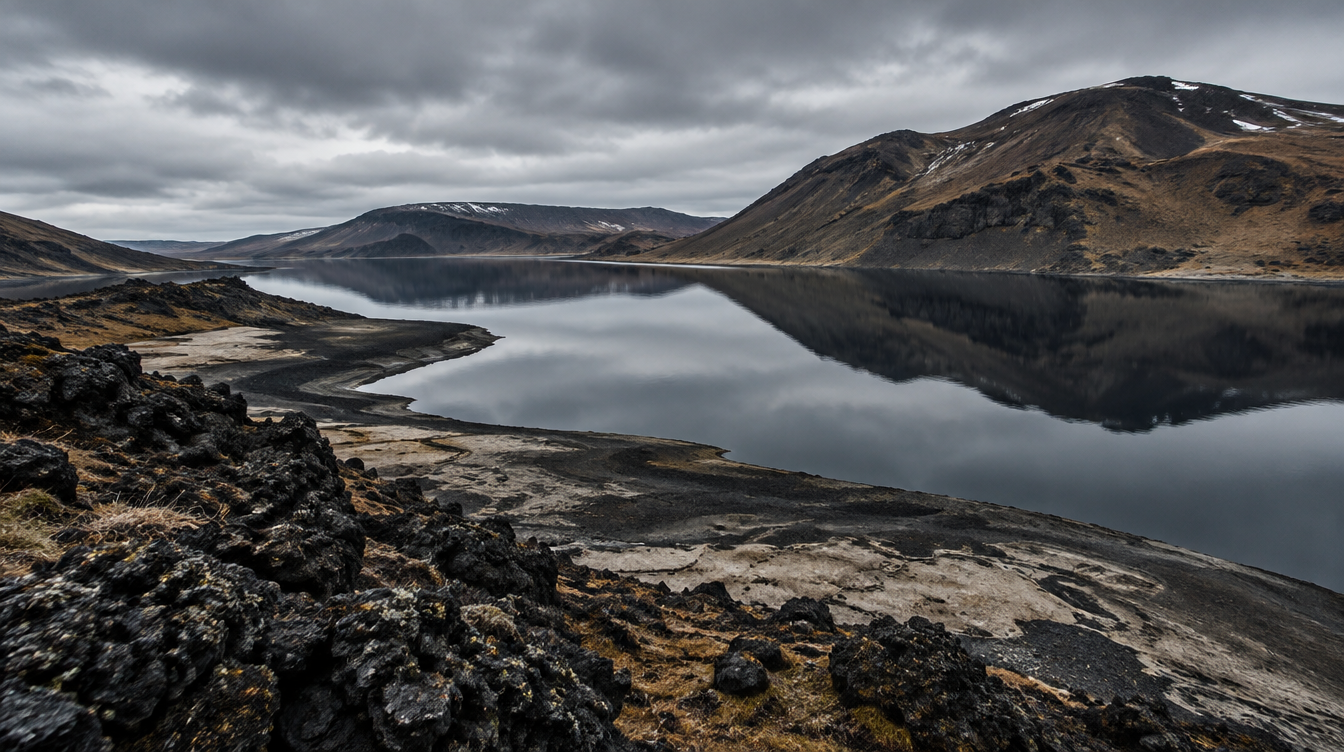
Kleifarvatn is a different kind of photograph entirely: a long, dark, largely empty lake a short drive inland from Garður, and the largest lake on the Reykjanes Peninsula (Wikipedia's entry on Kleifarvatn). It sits directly on the fissure zone of the Mid-Atlantic Ridge, which runs straight through this part of Iceland, and it has no visible inflow or outflow. Water moves through it almost entirely underground, seeping through porous volcanic rock rather than arriving or leaving by any visible stream, which is part of why the lake feels so still and self-contained when you stand at its shore.
The fact that makes this lake genuinely interesting to photograph is not aesthetic, it is geological. After the 2000 Iceland earthquakes, Kleifarvatn began shrinking, and it has not fully recovered since: at least 20 percent of its surface area has disappeared in the years following those quakes. A 2012 survey measured the lake's maximum depth at 89.5 meters, down from 97 meters recorded in 1975, and found at least one confirmed geothermal vent beneath the surface, with additional high temperature geothermal areas nearby. That survey also puts the lake's current surface area at roughly 7.36 square kilometers. None of that is visible at a glance, but knowing it changes how you look at the shoreline: those exposed stretches of dried lakebed you will notice in places are not seasonal, they are a lake that is still adjusting to an earthquake from a quarter century ago.
The wider setting reinforces that sense of an active landscape. The Reykjanes Peninsula is the onshore continuation of the Mid-Atlantic Ridge, home to between three and six distinct volcanic systems depending on how you count them, and some areas of the peninsula reach 100 degrees Celsius just half a meter below the surface (Wikipedia's entry on the Reykjanes Peninsula). Volcanic activity here resumed in 2020 after nearly 800 years of dormancy, and the Fagradalsfjall eruption that began on March 19, 2021 put this region firmly back on the map, followed by the evacuation of the town of Grindavík in November 2023 and further Sundhnúkur eruptions through 2023 to 2025. Kleifarvatn sits within that same restless geology, which is exactly why its own slow, ongoing shrinkage is worth knowing before you frame a shot of what looks, at first glance, like a perfectly calm, unchanging lake.
When to shoot Kleifarvatn
This is a stillness photograph more than a drama photograph. Early morning, before wind picks up off the open moorland that surrounds the lake, is when you have the best chance of a genuinely calm surface and a clean reflection of the dark hills on the far shore. A calm, overcast afternoon works nearly as well, since flat light softens the lake's already muted palette of black, grey, and deep blue-green without adding the harsh highlights a clear sky can throw onto water this dark.
Work the shoreline for foreground interest rather than shooting from a single fixed pullout. The exposed lava rock along parts of the shore, especially near the drying sections of lakebed mentioned above, gives you texture to lead a wide shot into the water, and a longer lens from the same spot can isolate the hills reflected on the surface into a much simpler, more minimal frame. In winter, partial ice at the lake's edges adds another layer worth watching for, though conditions vary enough year to year that you should treat it as a possibility rather than something to plan around.
| Attribute | Garður lighthouses | Kleifarvatn |
|---|---|---|
| Best time of day | Sunset through blue hour | Early morning, or calm overcast afternoon |
| What makes it distinct | Two lighthouses of different eras, 215 m apart, with open sea horizon | A shrinking lake on an active fissure zone, with no visible inflow or outflow |
| Main photographic risk | Strong, unsheltered coastal wind | Flat, uneventful light if you arrive at midday in full sun |
| Amenities | Small museum, limited parking at the point | None at the lake itself; nearest facilities are at Seltún |
| Time to budget | 20 to 40 minutes | 20 to 30 minutes |
Getting there and driving between them
Both spots sit on the northwestern end of the Reykjanes Peninsula, within the municipality of Suðurnesjabær, which was formed in 2018 from the merger of the towns of Sandgerði and Garður and covers about 85.4 square kilometers with a population of just under 3,600 (Wikipedia's entry on Suðurnesjabær). Keflavík International Airport itself sits about 3 kilometers west of Keflavík town and roughly 50 kilometers southwest of Reykjavík (Wikipedia's entry on Keflavík International Airport), which puts Garður close enough to the terminal that it genuinely functions as a detour rather than a destination in its own right. There is a small piece of aviation history tied to the area too: the airport was originally built partly as a replacement for a small wartime landing strip that had stood at Garður itself.
Kleifarvatn sits further inland and south, reached by driving through the peninsula's open, lightly populated interior rather than along the coast. Neither drive is long by Icelandic standards, but winter changes the calculation more than the distance on a map suggests. This stretch of the peninsula is flat and almost completely exposed, with no mountains to break crosswinds the way they are broken further inland, so a forecast that looks mild in Reykjavík can still mean a genuinely difficult crosswind on these open roads. Check conditions the morning of, not the night before, and build in extra time rather than planning a tight connection between either spot and a flight.
What to pack and plan for
Winter daylight on the Reykjanes Peninsula is short, the same short days that shape a visit anywhere else in Iceland at this time of year, so plan your stop at Garður or Kleifarvatn around the light you actually want rather than squeezing it in whenever the schedule allows. If golden hour or blue hour is the goal at Garður, build your arrival or departure day's timing around sunset specifically, not just "sometime in the afternoon."
Beyond timing, the practical list is short. A sturdy tripod matters more here than almost anywhere else on a typical Iceland itinerary, given how consistently exposed both locations are to wind. A lens cloth and a rain cover for your camera bag earn their keep on the coast at Garður, where sea spray is a near constant companion on anything but the calmest days. Dress for wind chill rather than the air temperature alone, since an otherwise mild winter day on this open point can feel far colder once the wind off the Atlantic picks up. Neither location has public facilities beyond Garður's small museum building, so plan accordingly before you set out, particularly at Kleifarvatn, where the nearest amenities are at Seltún.
Where this fits on a real itinerary
This is exactly the kind of stop that works best as part of a guided trip rather than a rushed solo detour on an exhausted arrival day. WeShoot's Iceland Winter Aurora tour is built around exactly this kind of logic: a 7 day, 7 night trip for a maximum of 10 participants, led by a professional photographer guide, that begins right at Keflavík Airport. The tour's own itinerary notes that the first aurora hunt of the trip often opens at Kleifarvatn and the Garður lighthouse, which is a far more useful way to experience these two spots than squeezing them in solo between baggage claim and a rental car return, with someone who already knows exactly where the light and the wind are going to cooperate that evening. The trip covers luxury accommodation throughout, all ground transportation and airport transfers, breakfasts and five dinners, plus coaching, image review sessions, and a post-processing workshop built into the schedule, for $4,500 per person with a $1,350 deposit. International flights and travel insurance are the traveler's own responsibility.
If you are building your own itinerary instead, the honest advice is the same one I gave at the start: do not carve out a dedicated day for Garður and Kleifarvatn. Fold them into the start or end of a trip that already has you driving near Keflavík, and treat the Reykjanes Peninsula as a bonus rather than a centerpiece. For photographers heading further around the country afterward, our guide to the Snæfellsnes Peninsula covers a very different kind of peninsula detour, one that is worth a full day in its own right rather than a quick stop, and our complete Iceland winter photography guide is the right place to see how a spot like this one fits into the bigger picture of planning a trip across the whole country.
Frequently asked questions
How do I get to Garður lighthouse from Keflavík Airport? It is a short drive north from the airport along the peninsula's coast road, close enough that most visitors fold it into an arrival or departure day rather than treating it as a separate outing.
Is there an entrance fee to visit the Garður lighthouses? The lighthouse point itself is freely accessible. The small maritime museum next to the site, which opened in 1995, may have its own hours and admission, so treat a museum visit as a bonus rather than something to plan your timing around.
What is the difference between the old and new Garður lighthouse, and which should I photograph? The original 1897 tower is shorter, closer to the water, and makes a cleaner minimalist subject. The 1944 replacement is taller, set further inland, and works better as the anchor of a wide shot that includes both towers. Photograph both if you have the time, since they read very differently in frame.
Is Kleifarvatn safe to walk around, and is there a complete trail circling the lake? The shoreline is walkable in sections, but conditions and path quality vary enough around the lake that you should not assume a continuous, maintained trail circles the entire shore. Stick to the areas near established pullouts rather than attempting a full circuit, especially in winter.
Is it safe to swim in Kleifarvatn? This is not a swimming destination and the guide question behind it usually comes from confusion with Iceland's geothermal pools elsewhere. Treat Kleifarvatn as a photography and viewing stop, not a place to get in the water.
Can you see the Northern Lights at Garður or Kleifarvatn? Both are plausible aurora viewing spots on a clear, active night, since this part of the peninsula has relatively little light pollution. At Garður specifically, account for the lighthouse's own working beam sweeping the sky periodically, which can intrude on a long exposure if you are not watching for it.
Do I need a 4x4 to reach these spots in winter? A standard rental car can usually manage both in normal winter conditions, since neither requires leaving paved or well maintained roads. That said, this is an exposed, flat stretch of the peninsula, so check the forecast the morning of your visit and be prepared to adjust if wind or ice conditions are worse than expected.
How long should I plan to spend at each location? Twenty to forty minutes at Garður, enough to work both lighthouses from a couple of angles, and twenty to thirty minutes at Kleifarvatn, since there is a single core composition from most accessible points along the shore rather than a wide range of distinct viewpoints.
Is Garður lighthouse actually worth visiting, or only if I am already nearby? Only if you are already nearby, and that is fine. It is not a spot worth a special detour from Reykjavík or anywhere else on the Ring Road, but as a free addition to a drive you are already making near Keflavík, it earns its place.
Sources
- Wikipedia: Garðskagaviti, history and specifications of both Garður lighthouses
- Wikipedia: Kleifarvatn, lake geology, depth, and post-earthquake water level history
- Wikipedia: Reykjanes Peninsula, volcanic geology and 2020-2025 eruption timeline
- Wikipedia: Suðurnesjabær, the municipality covering Garður
- Wikipedia: Keflavík International Airport, location and history
- Icelandic Meteorological Office: aurora and cloud cover forecast